- The City Sponge
- Posts
- Timely Local Flooding News Items
Timely Local Flooding News Items
Porous pavement in BK, FloodVision, DEP Townhall

The City Sponge: Flooding News ”Bits and Bobs” July 22 ‘24
Porous Pavement Testing in South Brooklyn
NYC is heavily cemented place. What if we could use our 12,000 miles of sidewalks and 6,000 miles of streets to help absorb water instead of just channeling it into overwhelmed sewers or flooded areas?
With that in mind, NYC officials are trialing a new type of porous pavement along select parts of a 7 mile stretch of South Brooklyn (green lines).
The test will measure if this type of cement (and underlying soil) can absorb up to a projected 35 million gallons of water to reduce flooding in these and surrounding areas.
Benefits of porous pavement (cited in USGS study and results):
Helps re-establish a more natural hydrologic balance and reduce runoff volume by trapping and slowly releasing precipitation into the ground
Reduces load on stormwater system at peak times
Reduces some pollutants being released untreated
BONUS: less road salt needed or deicing in the winter time - air trapped in the pavement can store heat and release it to the surface, promoting the melting and thawing of snow and ice
NOTE: Can get clogged after a year and may need power washing
Locations of the Brooklyn porous pavement test are Windsor Terrace, Prospect Park South, Ditmas Park, and include select parts of:
Parkside Ave
Marlborough, Rugby, Westminster Rds
Stratford Rd
Beverly Rd
East 9th St
East 8th St
East 5th St
Avenue C
Albemarle Rd / East 4th St
Vanderbilt St / 20th St
Terrace Place / Windsor Place
17th St
City announcement and explanation here: https://www.nyc.gov/site/dep/news/24-026/seven-miles-porous-pavement-being-installed-brooklyn-roadways-help-combat-flooding-and#/0
Someone send this to you? Please sign up so we can help you with flooding.
Seeing Your Place At Projected Flood Levels
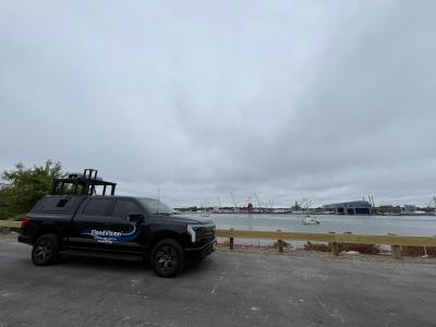
You may see this truck driving around NYC this week and its purpose is to help you visualize future flooding levels.

Climate Central FloodVision Truck (Camera Rig On Back)
Sometimes people need to see their own property…with water in it…to take action. So to help people visualize the realities of flooding projections, scientists at Climate Central (non-partisan, non-advocacy, non-profit), recently developed FloodVision: a tool that provides photorealistic visualizations of potential future flooding and precise entry-floor elevation measurements of buildings and structures. Think Google Street View, but for coastal flooding.
Cool examples here from New Hampshire:
While driving from Maine to Texas, they are in the NYC area the week of 7/22 (this week). They will also be meeting with journalists who wish to use the visuals and data, as well as community leaders, government officials, and scientists who are working on resilience.
We spoke to the FloodVision team who were looking for “hot spots” around Brooklyn /Gowanus area and have asked them to include some selected streets we know have a history of frequent flooding, including stormwater, sewer backup and underground water tables/rivers. With they are focussed on using data from coastal flooding now, they agreed to hit these streets on their tour in addition to Brooklyn coastal edges.

EVENT: DEP Flood Prep Town Hall: Free Mitigation Kits
What: DEP hosts a “Flood Preparedness Town Hall” with free mitigation kits.
Who: Open to public, registration not required.
Where: Patrick F. Daly Elementary, PS015 71 Sullivan Street, Red Hook, Brooklyn. Doors open 6pm, starts 6:30pm.
Why: They will be presenting what the city is doing to fortify neighborhoods in the face of climate change and giving tips for what you can do to protect your property. Also, providing attendees with free flood preparedness kits that include a sump pump, flood barriers and a flood sensor alarm. One kit per household. First come first served.
Questions: Email [email protected]

“When The Waterfront Is At Your Door” Community Meeting in Brooklyn
Over 30 people from the South Brooklyn Community recently gathered on July 13 to compare notes on flooding experiences and solutions they are looking into. It was hosted by The City Sponge and Forth on Fourth Avenue (FOFA).
To read about what we discussed and the ideas generated, click below.


Reply